A Significant Copper / Gold / Molybdenum Asset
Raye's primary asset is the New Nanik copper-gold-molybdenum prospect which yielded multiple >0.5% copper intersections in historical drilling.
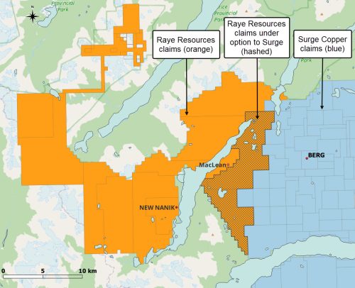
The prospect is only 17 kilometers from Surge Copper's 1 billion tonne Berg Cu/Mo porphyry deposit, currently undergoing pre-feasibility studies.
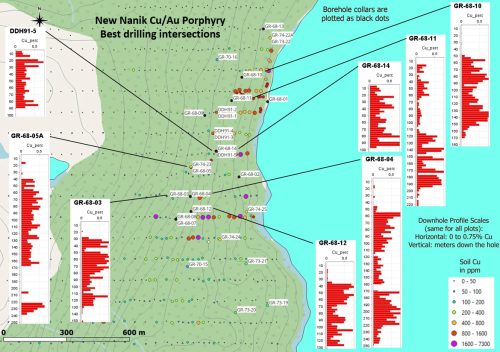
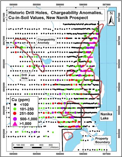
Past drilling has yielded multiple strong copper intersections over a 675 meter stike length which is open to the southwest. The copper is supported by material gold and molybdenum levels.
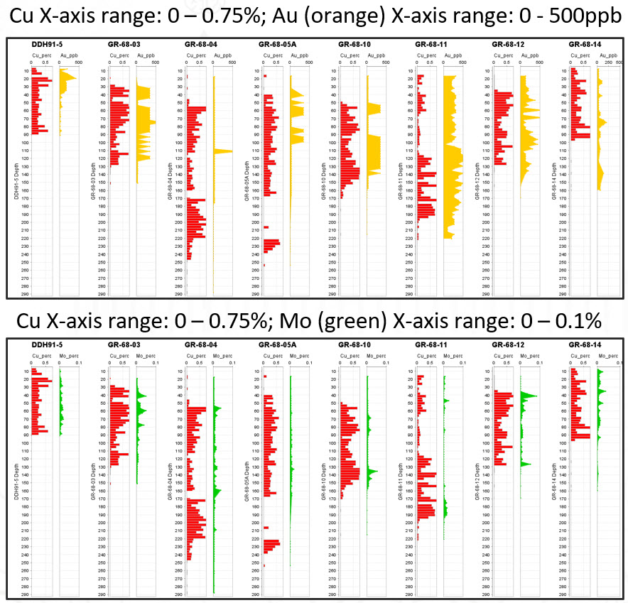
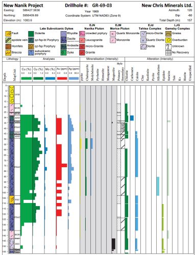
A graphical log of New Nanik drillhole GR-68-03 which intersected 97.54 meters running 0.46% Cu, 0.17g/t Au, 0.009% Mo, and 11.4g/t Ag can be viewed lower down on this page.
Target Summary and Location
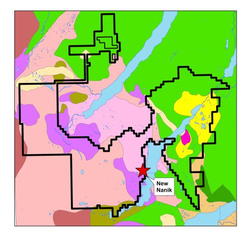
Geologically, the New Nanik prospect lies amongst a complex collection of intrusive rocks (pink to purple colours in the adjacent map), not far from inferred contacts with eroded, overlying volcanic rocks (greens).
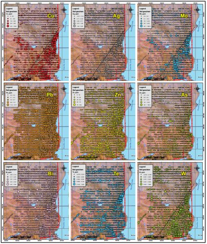
An extensive soil geochemistry survey conducted in 2012 yielded a copper-in-soil anomaly over two kilometers, with support from anomalies in a number of other pathfinder elements. Click on any of the maps below to enlarge it to full-screen.
The New Nanik target is planned for drilling in Phase 2 of the property exploration after a Phase 1 IP survey over the target area to refine drill siting.
Example Drillhole GR-68-03
An extract from Raye Resources Inc's 2024 43-101 report on the New Nanik Property describes its 1968 drilling results as follows:
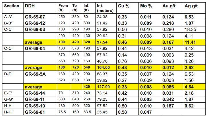
"Quintana Minerals completed the first documented work on the New Nanik prospect since its apparent discovery in the 1920’s... They drilled 14 holes in 1968,which they interpreted to define a tabular zone of mineralization up to 500’ (152 m) thick, by 3,200’ (975 m) long. Hole #4 cut an interval 160 feet long (48.8 m) that graded an average of 0.75% Cu at depth, which the reporter interpreted to suggest that better grades could be encountered deeper. Shear (1968) estimated an average grade of greater than 0.44% Cu across several drill holes. Intervals from several drill holes, tabulated in Table 4 from the drill sections such as shown in the table below, display impressively long intervals of mineralization with significant grades averaging ca. 0.45% Cu."
An example downhole borehole profile (GR-68-03*) is shown in this illustration.
*In certain historical documents, boreholes drilled in 1968 and reported in 1969 used "69" in their reported labels.
Commercial Success Consideration
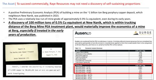
A positive Preliminary Economic Analysis (PEA) of building a mine on the ~1 billion tonne Berg porphyry copper deposit, which neighbours New Nanik, was published in 2023.
The PEA uses a relatively low run-of-mine grade of approximately 0.3% Cu equivalent, even during its early years.
A discovery of 100 million tonnes of 0.5% Cu equivalent at New Nanik, which is within trucking distance of the Berg Mine PEA treatment plant, would materially improve the economics of a mine at Berg, especially if treated in the early years of production.
As early as 1972 a consultant reviewing New Nanik drilling results recommended a target of 100 million tons at 0.43% copper.

